From the image you want,
to where and when to shoot.
Sidekick Planner
The moment the sun sits on a summit or the tip of a tower. Start from a place or start from a date — Sidekick Planner works out the "when and where" either way. Shot-planning software for photographers.
The download is about 2 GB — it bundles the 2027 annual planning data
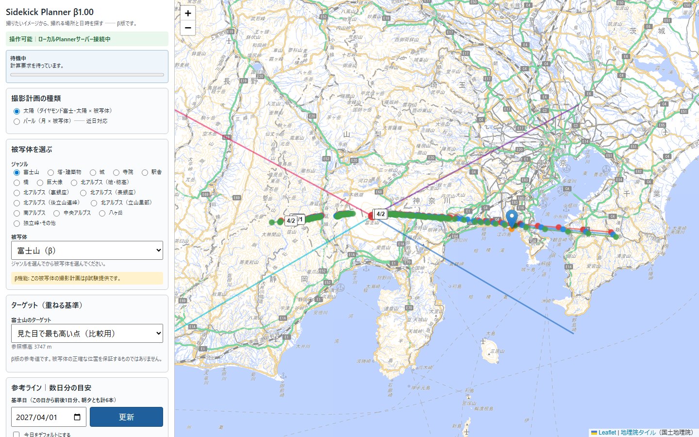
What Sidekick Planner does
The position of the sun, the coordinates of the landmark, the terrain in between. Once the date and the place are fixed, these can be computed — so let the computer do it, and keep the photographer's attention on the shot.
Search from either end
"Where should I stand on this date?" and "When will it line up from this spot?" — a shooting plan rarely settles from one direction alone. Go back and forth on the map until it does.
Check the view before you go
A composition preview draws the skyline from elevation data and overlays the sun's track and your lens's field of view. See whether a nearer ridge blocks the subject, and where it lands in the frame.
Take the plan with you
Share a finished plan as a QR code. Opened in a smartphone browser, it shows the date and time, the shooting point, the composition image and the geometry on one screen.
Some things can be computed; some can only be seen on site — weather, transparency, the light of that day. Sidekick Planner computes ahead as far as the photographer can then judge on the ground. For the rest, you go there.
What beta 1.01 can plan
Beta 1.01 covers "sun × landmark" plans. Diamond Fuji is the flagship example, but the subject is not limited to Mount Fuji.
Diamond Fuji
The sun on the summit of Mount Fuji. For both sunrise and sunset, the bundled annual data gives the dates and the shooting points where it lines up.
Sun × 100 landmarks
Mount Fuji; peaks of the Northern, Southern and Central Alps and Yatsugatake; towers and tall buildings; castles; temples; bridges; a station; giant statues — 100 subjects in all, chosen by genre.
Each subject offers "targets" (summit, tip, …) so you decide exactly where the sun should sit.
Pearl (moon × landmark)coming soon
Plans that place the moon on a landmark are coming soon. Beta 1.01 shows the option, but the calculation cannot be started yet.
From a place. From a date.
Sometimes the place comes first, sometimes the date. Sidekick Planner has an entrance for each.
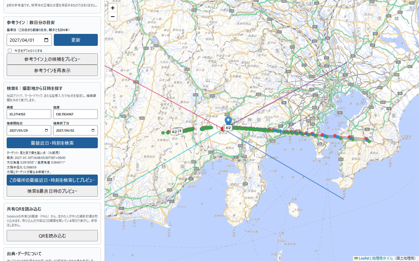
From a place to a date (Search B)
Set the shooting point by clicking the map, dragging the pin or typing coordinates, choose a period, and Planner finds when the sun comes closest to the target of your subject.
- Azimuth difference, altitude difference and solar-radius ratio tell you whether it really overlaps
- Jump straight from the result into the composition preview
- Refine the standing position in 50 m steps
From a date to a place (reference lines)
Choose a base date and Planner draws, for the days around it, the lines of shooting points where the sun lines up with the subject — one for the morning and one for the evening. Pick a candidate on a line and preview it.
Check the view before you leave.
Once you have a candidate, Planner draws how the subject will look from that point. The skyline comes from Geospatial Information Authority of Japan elevation data, the sun's position from the ephemeris.
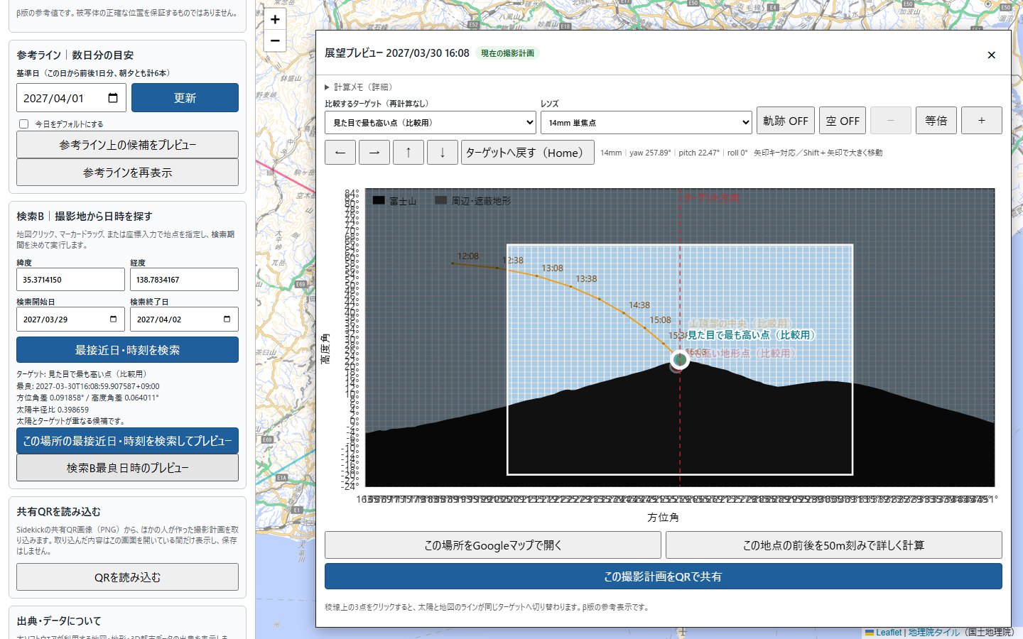
Hidden by terrain?
The terrain between you and the subject is drawn as a skyline. Candidates blocked by a nearer ridge show up here.
Lens and field of view
Switch lenses and the frame changes. Pan and tilt with the arrow keys to see where the subject and the sun fall in the frame.
Confirm the point on the map
Candidates, the shooting point and the reference lines stay linked to the map. "Open in Google Maps" checks access to the spot.
Your plan, on your phone, by QR.
A plan made on the PC can be shared as a QR code. The phone that scans it opens the plan in its browser — no app to install.
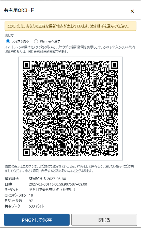
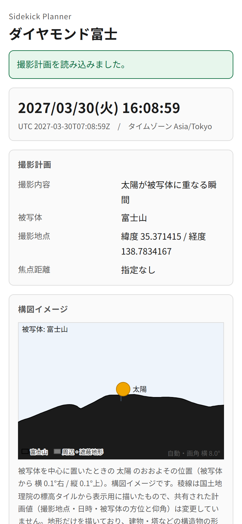
View on a phone
Scanning the QR opens a Sidekick Lab share page in the browser: date and time, shooting point, subject, composition image and the geometry between point and subject. One screen to look back at on site.
Hand to another Planner
Load the QR image in Sidekick Planner on another PC to see that plan on the map — for comparing candidates with friends.
Getting started
Download the beta
Register an e-mail address to reach the download page. Unzip — there is no installer.
Launch
Run SidekickPlanner.exe and the Planner screen opens in your browser. An internet connection is needed for map and elevation tiles.
Pick a subject and search
Choose Mount Fuji and a date and the reference lines appear on the map. Refine a spot with Search B and check it in the preview.
About beta 1.01
A public test release ahead of Version 1, provided free of charge so you can try how it works.
| Version | Sidekick Planner Beta 1.01 (1.0.0-beta.2) |
|---|---|
| Operating system | Windows 10 (64-bit) or later. There is no macOS version. |
| Language | The product UI of the initial public beta is Japanese only. The Terms of Use and the Privacy Policy are available in English. |
| Price | Free during the beta period. Beta usage does not count toward any free period of a future paid release. |
| Beta period | From the public release date until 31 October 2026, Japan time (the currently planned end date). After the planned end date, the beta (beta 1.01 and later) can no longer be started. The end date may change with the progress of development and testing (an extension is delivered as a new beta version). |
| Download size | About 2 GB (ZIP). It bundles the 2027 annual planning data (year-round track data for the main subjects), which is why the download is this large — and why searches run entirely on your PC. |
| Code signing | The current beta is not code-signed; a code-signing certificate is being obtained. Windows / Microsoft Defender SmartScreen may show a warning when you launch it. The only official source is this Sidekick Lab download page. |
| Terms |
Sidekick Planner Beta Terms of Use /
Privacy Policy (Sidekick Planner section) The beta program itself may not be redistributed. To introduce it, share a link to this page. |
Have the next Diamond Fuji computed in advance.
Beta 1.01 is free. If you notice anything while using it, please let us know.
Windows 10 (64-bit) or later ・ about 2 GB ・ Japanese UI
Terms of Use ・ Privacy Policy ・ FAQ